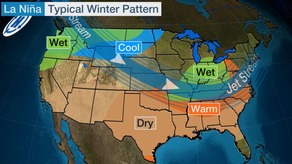
The Pacific Ocean is currently experiencing a weather phenomenon, called La Niña, where the temperatures of the water are cooler. La Niña creates weather phenomena around the world; this includes phenomena such as warmer and drier winters for Georgia. Scientists are measuring and tracking the temperatures of the Pacific.
University of West Georgia professor, Dr. Shea Rose teaches meteorology classes and provides insight into La Niña.
“It’s part of the El Niño Southern Oscillation (ENSO),” said Dr. Rose. “It’s an atmospheric-oceanic relationship that is occurring over the Pacific Ocean. The oceans and atmosphere are highly linked. The Pacific Ocean is huge, so [La Niña] has impacts worldwide.
“We look at the broad trends with this,” continues Dr. Rose. “This is a climate feature. What we have seen historically is that when we have a La Niña in place, we tend to see drier and warmer temperatures in our region.”
La Niña is known as an extreme phase of the Enso cycle. The opposite extreme is known as El Niño. These cycles are Quasi-periodic, which means they will occur once every three to seven years. La Niña and El Niño are naturally occurring phenomena.
“When you have La Niña set up, trade winds are typically a little stronger than normal,” said Dr. Rose. “This is all related to pressure changes and temperature changes in the ocean. There’s some shifting of pressure and temperature over the Pacific Ocean. One thing you can see is the cooling of the ocean temperature as the trade winds are pushing the warmer waters to the western side of the Pacific.”
Typically, these cycles do not occur back-to-back each year; however, this year’s La Niña is what is known as a “double dip” La Niña, according to Dr. Rose.
“That means that we just had one and we came out of it over the summer and we’re going right back into it,” said Dr. Rose. “If we look at last year’s winter, it was a little drier than normal, warmer than normal. [This winter] might be very similar.”
A rarity in the state of Georgia is the possibility of getting snow in the wintertime. With La Niña, that possibility is not entirely lost. A prime example of La Niña would be the winter of 2020. Christmas Day in Carroll County had temperatures in the mid 60s, rather than our usual temperatures of the 50s or below. January of 2021 yielded slight snowfall in northern Carroll County, as well as the northern counties in Georgia.
“Having the right temperature, the right moisture conditions and surface temperatures, it could happen,” said Dr. Rose. “What goes on with our jet stream and our polar vortex; those you have to watch. If the right situation comes up, we could have snow even though overall you may still have warmer temperatures on average. That doesn’t mean we won’t.”
You may also like
-
UWG’s Ingram Library Hosts Pop-Up Study Spot to Help Students Prepare for Finals Week
-
UWG Offers Mental Health Support And Academic Services To Maintain Student Success During Finals Week
-
UWG Alumnus Shares His Experience Exploring the Underground Flood Channels of Las Vegas
-
Georgia Students Simulate the Struggles of Dementia
-
UWG PR Students Score a Georgia Power Tour at Atlanta Corporate Office
